A BRIEF HISTORY
Long Island City - the western shore of Queens - is the largest community in the borough. Its borders are the East River to the north and west, Newtown Creek to the south, and 51st/Hobart Street to the east.
Its rich farm land encouraged early settlement (1640s). Throughout the nineteenth century, the community supplied flowers to hotels in New York; some claim an Astoria farm grew the first broccoli in America!
Transportation spurred dynamic growth. The Village of Astoria started around Manhattan's 92nd Street Ferry, and the Hunters Point district developed around the Long Island Rail Road.
Long Island City, chartered in 1870, existed only 28 years. In the consolidation of 1898, it was swallowed up by the City of New York.
The area became fully developed with the spread of trolleys and, later, with the construction of the subway and elevated lines (1870 - 1940).
But the secret to this community's success is more than excellent location.
It has always been home to creative people and innovative ideas. Chester Carlson invented the Xerox process in a lab at 37-02 Broadway. The modern piano developed at the Steinway Piano Factory. The Paramount (now Astoria) Movie Studios remain the premier East Coast film and movie production facility.
The Noguchi Museum, P.S. 1 Studios, Socrates Sculpture Park, the Silvercup Studios, the American Museum of the Moving Image, and the growth of a new community of arts have revived the name - “Long Island City.”
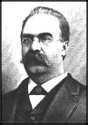
STEVEN HALSEY (1798-1875)
Known as the "Father of Astoria," Halsey moved to Hallet's Cove in 1835 and conceived the idea
of founding a new village with dwellings, stores, factories, schools, and churches. After obtaining a village charter
from Albany in 1839, he started a ferry to Manhattan, and created Astoria Blvd. and Vernon Ave. He named the village
'Astoria' after fellow fur merchant John Jacob Astor.
DR. DOW DITMARS (1771-1860)
Dr. Ditmars, a son of one of the earliest colonial Dutch families, was born in Brooklyn
and went to Princeton. He spent 12 years in British Guiana, South America. The good doctor settled in Astoria
and practiced medicine for nearly 50 years dying at 90. He lived in a mansion at the Hell Gate on the street that
today bears his name. A son later became Mayor of Long Island City.
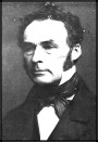
WILLIAM STEINWAY (1836-1896)
William moved the family piano business from Manhattan to Queens, and created housing,
stores, churches and schools for the workers. Active in civic affairs, Mr. Steinway developed the Steinway Tunnel,
North Beach, street railways and real estate, and as head of the Subway Commission, planned the NYC subway
network.
NEWTOWN CREEK
The route to Queen's earliest settlements, at Maspeth (1642) and Dutch Kills (1643), its banks boasted Queens' richest farms until overwhelmed by the arrival of the L.I.R.R. and industry about 1850. In the mid-1900s, this little stream carried more tonnage than the Mississippi River! Awaiting development, historians want to preserve some of its industrial heritage.
SUNSWICK CREEK
Sunswick (from "Sunkisq" - American Indian for "sachem's wife") was a tidal marsh that started at the East River and 30th Drive, and extended along 21st Street to beyond Queens Plaza. Drained after 1890.
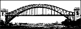
Named by the Dutch 'Hellgat' meaning either 'hell' or 'bright channel.' A narrow strait between Astoria and Ward's Island, connecting the East River with Long Island Sound. For many years the waterway was hazarous with powerful tides and rocky outcroppings. In 1780, a British pay ship sank, whose gold and silver is still sought by divers. In 1876, the Army Corps of Engineers blasted out most of the rocks with what was then the world's largest denoted explosion. The Hell Gate bridge is from 1917; Tribourogh from 1933.
Today, this is the location of our community's 60 acre Astoria Park , a place of breath-taking natural beauty and home to many concerts and festivals.
ONE SIDEWALK CLOCK
In 1922, Edward Wagner, who had a jewelry store at 30-78 Steinway Street, purchased a second-hand sidewalk clock in Manhattan and moved it to this location. One of 7 in NYC, and 2 in Queens, it is a NYC designated landmark!
TWO MILL STONES
Mill Stones from Burger's Sluice(c. 1648-1657)
A ditch, called 'Burger's Sluice' ran from 48th Street to Queens Plaza, paralleling Northern Blvd. Feeding a pond whose level rose and fell with the tides, the water turned the wheels that ground grain into meal or flour. It was the first mill in this part of Long Island. When the L.I.R.R. destroyed the building in 1861, the stones were moved to the sidewalk in front of the Paytar House (1720-1917) on Northern Blvd. They were relocated to their present spot in front to the old Long Island Saving Bank on Queens Plaza North about 1920. Brought over from Holland about 1650, these mill stones are the oldest European artifacts in Queens.
THREE COLONIAL ROADS
[1] 20th Road was known as 'The Bowery Bay and Out Plantations Road" when laid out in 1638-50.
[2] Only the first block (46th St./Newtown Rd.) and last block (29th St./38th Ave.) of Ridge Road remains. Connecting the hamlets of Middleton and Duch Kills, it may
be from 1640-54.
[3] Newtown Road/Avenue connected the Hallet Farm at Hallett's Cove with the 'Road to Newtown' (Woodside Ave.) and the 'Road to Bowery Bay' (51st/Hazen St.) Laid out after 1652.