|
|
Stuyvesant Square Park,
uniquely bisected by Second Avenue between East 15th and East 17th
Streets in Manhattan, is the center of one of the most handsome and historic neighborhoods
in New York City. It is named for Petrus (Peter) Stuyvesant, the last Director-General of
the Dutch colony of New Netherlands.
"Old
Silver Nails," peg-legged and irascible, was evidently an efficient Director but not
very popular among his constituency of proximately 1,500. His tenure, begun in 1647, ended
in 1664 when it was his misfortune to be ordered to hand over is city to the British. Such
was his reputation tat a fleet of ships was sent to ensure that the accords reached far
away in Europe would be honored peaceably.
The
Director was a man of wealth and property. His farm, or "bouwerie" in Dutch, of
some 120 acres extended from what is now East 10th Street to East 23rd
Street, and from First Avenue to Fourth Avenue, Union Square East, and Park Avenue South.
It was the a pastoral place of rolling meadows, woodlands, ponds, rocky hills, waterfalls,
and streams – far removed from the settlement at the Battery. Indeed, the property
bordered directly on the East River, in that distant time before extensive landfills
reshaped Manhattan.
The
Director’s manor house, surrounded by outbuildings for his many servants, was
situated with a clear view of the river just west of the present intersection of Second
Avenue and East 10th Street. Close by, the site of his chapel is marked today
by St. Mark’s Church in-the-Bowery, and the famous Dutchman lies there still in the
family vault.
During
the 18h century, urban New York’s northward thrust steadily approached what was then
"Petersfield," so named by great-grandson Petrus S. Stuyvesant. In 1789, this
enterprising namesake, much like any modern developer, mapped a portion of his inheritance
into housing lots and proceeded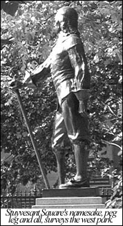 to build. to build.
His
street plan was laid out in a true north-south direction, however, and the work was
largely erased when, in 1811, the city adopted its own street grid to conform with
Manhattan’s northwesterly bias. All was absorbed into the new plan except Stuyvesant
Street, connecting to Bouwerie Road (Third Avenue) with St. Mark’s Church. Because of
its beautiful houses and access to the church, the street was left as it was, and is
today.
The
Stuyvesant mansion stood on a river promontory roughly east of First Avenue between East
15th and East 16th Street, and city directories of the day list many
members of his family living nearby. His daughter Elizabeth married Major Nicholas Fish, a
distinguished Revolutionary officer, and lived at 21 Stuyvesant Street, a landmark today.
Hamilton Fish, Governor of New York and later Secretary of State, was their son.
Great-great-grandson Peter Gerard Stuyvesant and his wife
Hellen Rutherford owned the still largely open land lying between First and Third Avenues
and East 12th and East 20th Streets. It was they who created
Stuyvesant Square, deeding the site to the city in 1836.Next
> |
|