Civic
Association
Staten Island,
New York

| St. George
Civic Association Staten Island, New York |
|
|---|

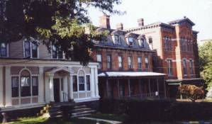
The St. George Historic District, which includes portions of St. Marks Place, Carroll Place, Westervelt Avenue, and Hamilton Avenue, the Phelps Place cul-de-sac, and short stretches of Richmond Terrace, is a small enclave containing some 78 buildings, part of a larger suburban development, located along Staten Island's North Shore. Predominantly late nineteenth century in character, the area of the district had its roots in one of the earliest planned suburban communities in New York City. Initiated by Thomas E. Davis, a wealthy Manhattan real estate developer, in 1834-35, the project was taken over in 1836 by the New Brighton Association, a consortium of wealthy New York City entrepreneurs who promoted this location as a commuter suburb called New Brighton which was readily accessible to New York City by steamboat ferry service. The proposed development slowed, almost immediately affected by the economic collapse of 1837; within the historic district, however, part of the existing street pattern reflects that shown on the plan of New Brighton of 1835 - three crescent-shaped streets ascending a steep hillside and another that surrounded them. The present street names are those shown on that original plan: Richmond Terrace, Carroll Place, St. Marks Place, and Hamilton Avenue (its original westernmost end is today part of Westervelt Avenue). In addition, there are four structures from this earliest phase of development. The oldest structure in the district is the house at 404 Richmond Terrace (now "Pavilion on the Terrace"), a temple-fronted Greek Revival residence built c. 1835 by Thomas Davis and acquired shortly thereafter by Henry P. Robertson, a Manhattan merchant. Another early house remains at 272 Richmond Terrace, originally part of a grouping of three similar houses constructed c. 1839-45 by Henry McFarlane. Also surviving are two early carriage houses that were built to serve houses on Richmond Terrace.
In the 1840s and 1850s New Brighton developed into a fashionable summer resort. One Italianate villa, now modified, at 97 St. Marks Place and two large brick Italianate outbuildings on the north side of Carroll Place survive from this period.
A Civil War business boom brought new development and a population increase to Staten Island as New York's populace sought affordable housing. Among the most notable houses built in the area of the historic district was the Anson Phelps Stokes residence (1862), one of three large estate houses constructed at the top of the hill on land between St. Mark's Place and Hamilton Avenue. This period was marked by the introduction of a new building type to the district, the double house, and a new style, the Second Empire. Several houses dating from the 1860s and early 1870s, designed in this style and distinguished by their mansard roofs, are located on Westervelt Avenue and the north side of St. Mark's Place. This period of development was halted by the Depression of 1873.
 Sometime between 1878 and 1882, the
saloon and hotel keeper Joseph Wilks built the brick double house at 30-32
Westervelt Avenue which shows the influence of the Romanesque Revival style.
The increase in building activity within the district starting in the 1880s
coincided with the consolidation of competing Staten Island ferry lines at one
location, the site of the present St. George ferry terminal. Improved
transportation, making the area more convenient to lower Manhattan, was the
primary impetus for the suburb's development boom. The story has been told that
the appellation, St. George, which first appears on an 1885 map, was the name
that ferry promoter Erastus Wiman gave to the terminal, after George Law, a
railroad engineer and financier, made land available for the new railroad and
new terminal.
Sometime between 1878 and 1882, the
saloon and hotel keeper Joseph Wilks built the brick double house at 30-32
Westervelt Avenue which shows the influence of the Romanesque Revival style.
The increase in building activity within the district starting in the 1880s
coincided with the consolidation of competing Staten Island ferry lines at one
location, the site of the present St. George ferry terminal. Improved
transportation, making the area more convenient to lower Manhattan, was the
primary impetus for the suburb's development boom. The story has been told that
the appellation, St. George, which first appears on an 1885 map, was the name
that ferry promoter Erastus Wiman gave to the terminal, after George Law, a
railroad engineer and financier, made land available for the new railroad and
new terminal.
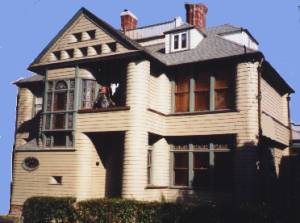 The majority of houses in the historic
district were constructed in the 1880s and 1890s and reflect a combination of
the decorative Queen Anne style and aspects of the Colonial Revival and Shingle
styles; it is these houses which give the district its predominant
architectural character. Most of the houses are wood-frame structures with
clapboard or shingle siding, although there are some masonry buildings. Taking
advantage of the hilly topography, the houses are designed with picturesque
features such as comer towers, projecting bays, and porches which add
architectural variety. The houses on the south side of St. Marks Place, for
example, are set uphill and back from the street while those on the north side
of the street are located on narrow, deep lots running downhill to Carroll
Place and have additional stories at the rear. Historically Carroll Place was
lined with outbuildings related to the properties on St. Marks Place and
Richmond Terrace. A few of the surviving buildings on Carroll Place, such as
those at Nos. 9, 17, and 135, appear on an 1874 map; they were subsequently
converted for residential use. Other buildings on Carroll Place are garages for
the properties on St. Marks Place.
The majority of houses in the historic
district were constructed in the 1880s and 1890s and reflect a combination of
the decorative Queen Anne style and aspects of the Colonial Revival and Shingle
styles; it is these houses which give the district its predominant
architectural character. Most of the houses are wood-frame structures with
clapboard or shingle siding, although there are some masonry buildings. Taking
advantage of the hilly topography, the houses are designed with picturesque
features such as comer towers, projecting bays, and porches which add
architectural variety. The houses on the south side of St. Marks Place, for
example, are set uphill and back from the street while those on the north side
of the street are located on narrow, deep lots running downhill to Carroll
Place and have additional stories at the rear. Historically Carroll Place was
lined with outbuildings related to the properties on St. Marks Place and
Richmond Terrace. A few of the surviving buildings on Carroll Place, such as
those at Nos. 9, 17, and 135, appear on an 1874 map; they were subsequently
converted for residential use. Other buildings on Carroll Place are garages for
the properties on St. Marks Place.
 The Phelps Place cul-de-sac is
located on what was once the Anson Phelps Stokes estate. The double houses at
7-8 and 9-10 Phelps Place, as well as the freestanding house at 11 Phelps
Place, were all designed by Manhattan architect Douglass Smyth and built c.
1890. They display elements of the popular Shingle style as adapted to
speculatively developed suburban architecture.
The Phelps Place cul-de-sac is
located on what was once the Anson Phelps Stokes estate. The double houses at
7-8 and 9-10 Phelps Place, as well as the freestanding house at 11 Phelps
Place, were all designed by Manhattan architect Douglass Smyth and built c.
1890. They display elements of the popular Shingle style as adapted to
speculatively developed suburban architecture.
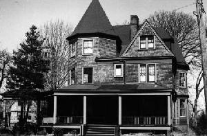
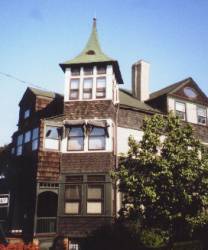 The district is also notable for the
large number of works from this era designed by Staten Island architect Edward
Alfred Sargent (1842-1914). Examples of Sargent's work within the district
include the houses at 103, 115, 119, and 125 St. Marks Place, dating from c.
1890, which show the influence of the Shingle style. No. 103 was built for
banker Frederick L. Rodewald, while Nos. 115 and 119 were built for Vernon
Brown, a shipping agent for Cunard Lines. No. 1-5 St. Marks Place (c. 1887-91)
and No. 27 St. Mark's Place (1906) are also documented as having been designed
by Sargent, as were the c. 1890 alterations to the earlier house at No. 75
which included the addition of the porch and projecting bays.
The district is also notable for the
large number of works from this era designed by Staten Island architect Edward
Alfred Sargent (1842-1914). Examples of Sargent's work within the district
include the houses at 103, 115, 119, and 125 St. Marks Place, dating from c.
1890, which show the influence of the Shingle style. No. 103 was built for
banker Frederick L. Rodewald, while Nos. 115 and 119 were built for Vernon
Brown, a shipping agent for Cunard Lines. No. 1-5 St. Marks Place (c. 1887-91)
and No. 27 St. Mark's Place (1906) are also documented as having been designed
by Sargent, as were the c. 1890 alterations to the earlier house at No. 75
which included the addition of the porch and projecting bays.
As the governmental and business center developed near the ferry terminal in the years after Staten Island was consolidated into Greater New York, the larger neighborhood including the area of the district came to be known as St. George. Suburban development continued in the district as the owners of large estates died and the heirs sold off the properties. The freestanding frame houses from this period, many of them on the east side of Westervelt Avenue and on Hamilton Avenue, continue the stylistic trends established by Sargent and his contemporaries in the 1890s.
Also included within the district are examples of non-residential architecture which contribute to its character. The neo-Romanesque St. Peter's Roman Catholic Church, built in 1900-01 to the designs of Harding & Gooch, on the site of an 1844 structure which had been Staten Island's first Roman Catholic church, dominates the view down St. Mark's Place. Two one-story commercial buildings, faced in decorative terra cotta and built along the west side of Westervelt Avenue, are typical of small stores constructed in suburban residential neighborhoods during the 1920s and '30s.
The historical significance of the St. George Historic District comes in part because of its prominent residents over several generations, including many leading members of the arts, professions, and business community, political and social leaders, and founders of such important local institutions as the Staten Island Institute of Arts and Sciences and the Staten Island Women's Club.
The architecture of the district reflecting several distinct eras of suburban development on Staten Island, the curving streetscapes, the distinctive topography, and the terraced landscape all work together to give the area its special character.
Go to St. George Civic
Association
last rev. January 2 2004
by
David Goldfarb